San Francisco, CA: March 17-21, 2026
The SAM Business Meeting was held during the AAG Annual Meeting on March 19, 2026. Outgoing Chair Hyun Kim shared the specialty group's activities and financial report for the 2025-2026 year. In addition, the following SAM community members were recognized:
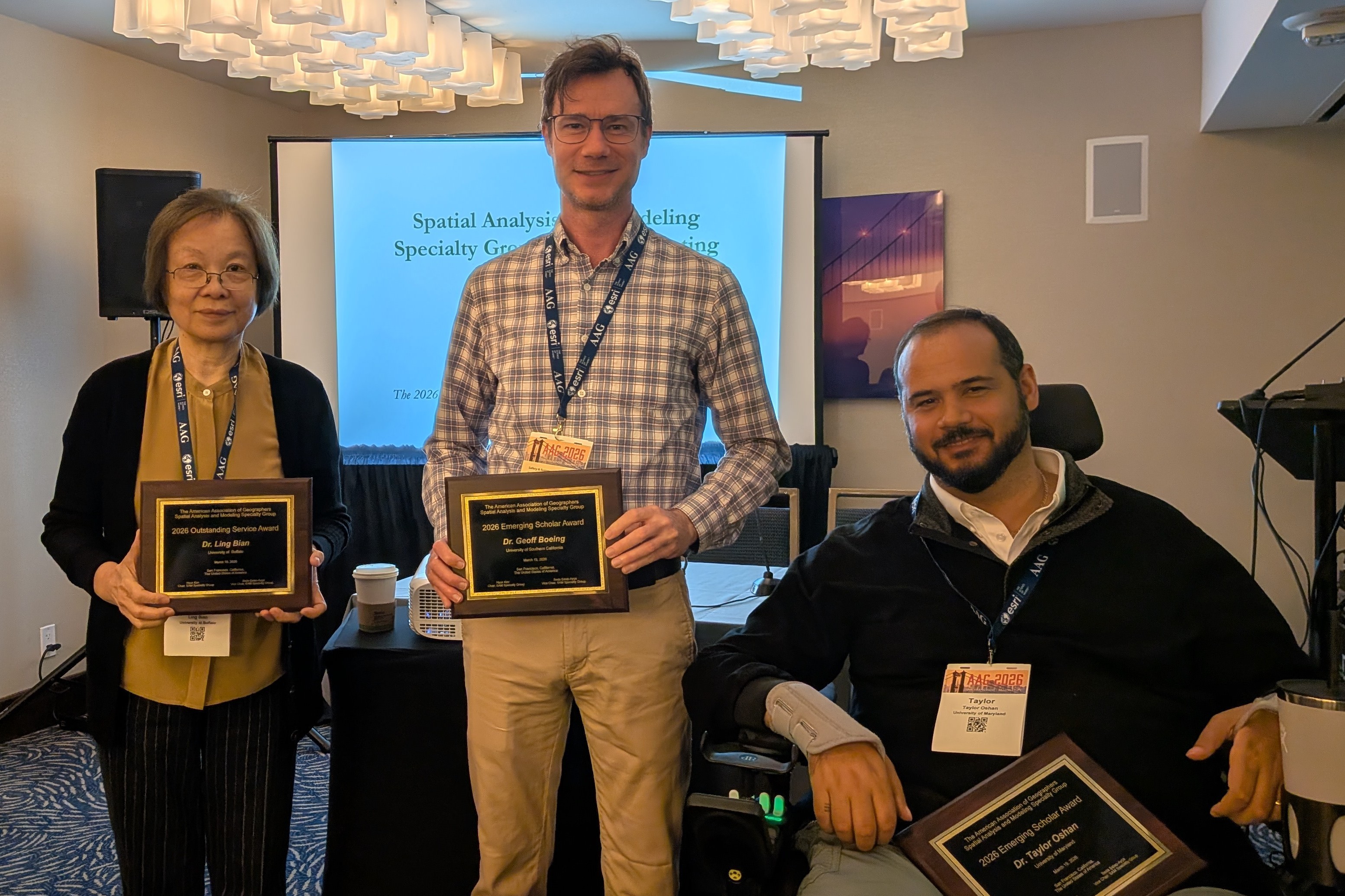
Ling Bian, Geoff Boeing, & Taylor Oshan
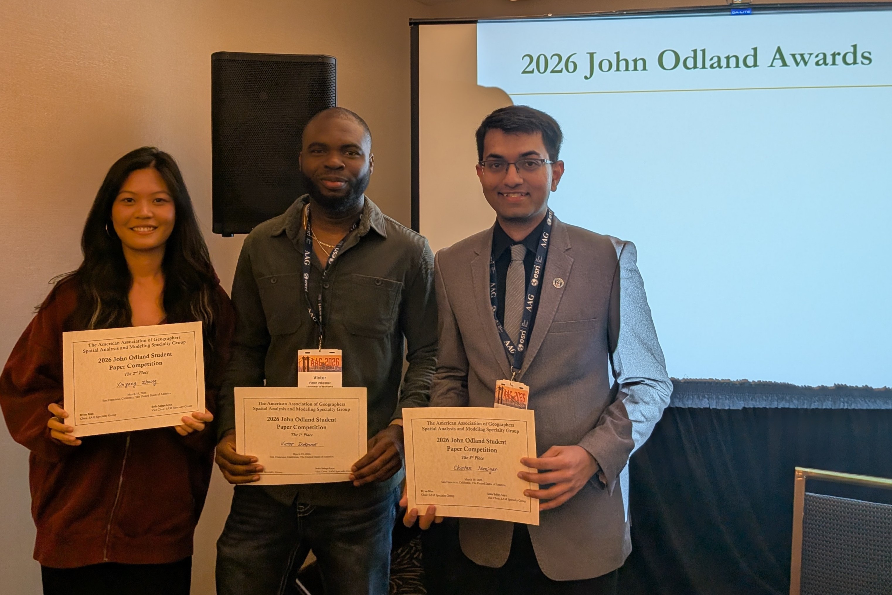
Xinyang Zhang, Victor Irekponor, & Chintan B. Maniyar
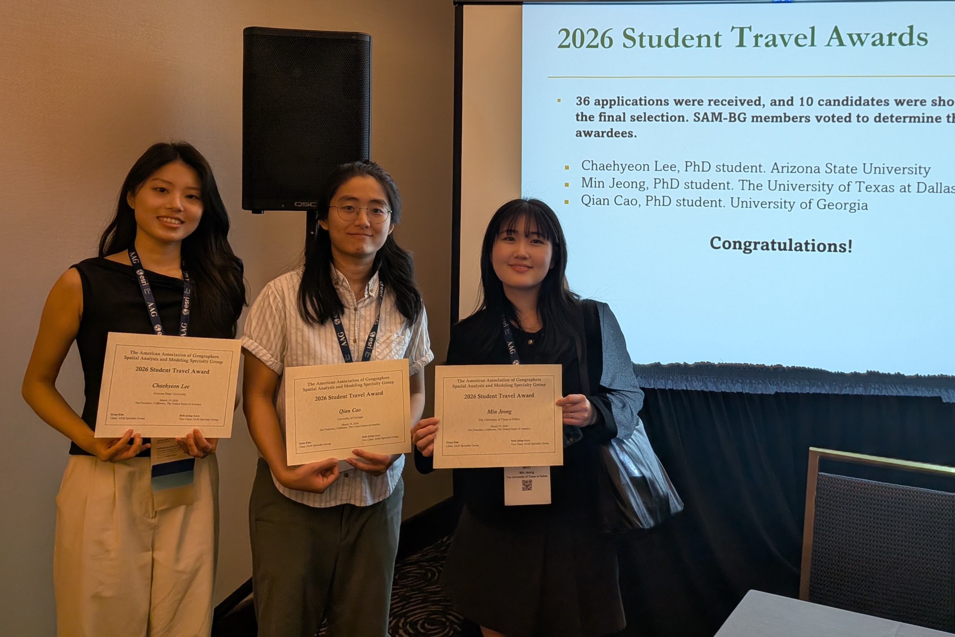
Chehyeon Lee, Qian Cao, & Min Jeong
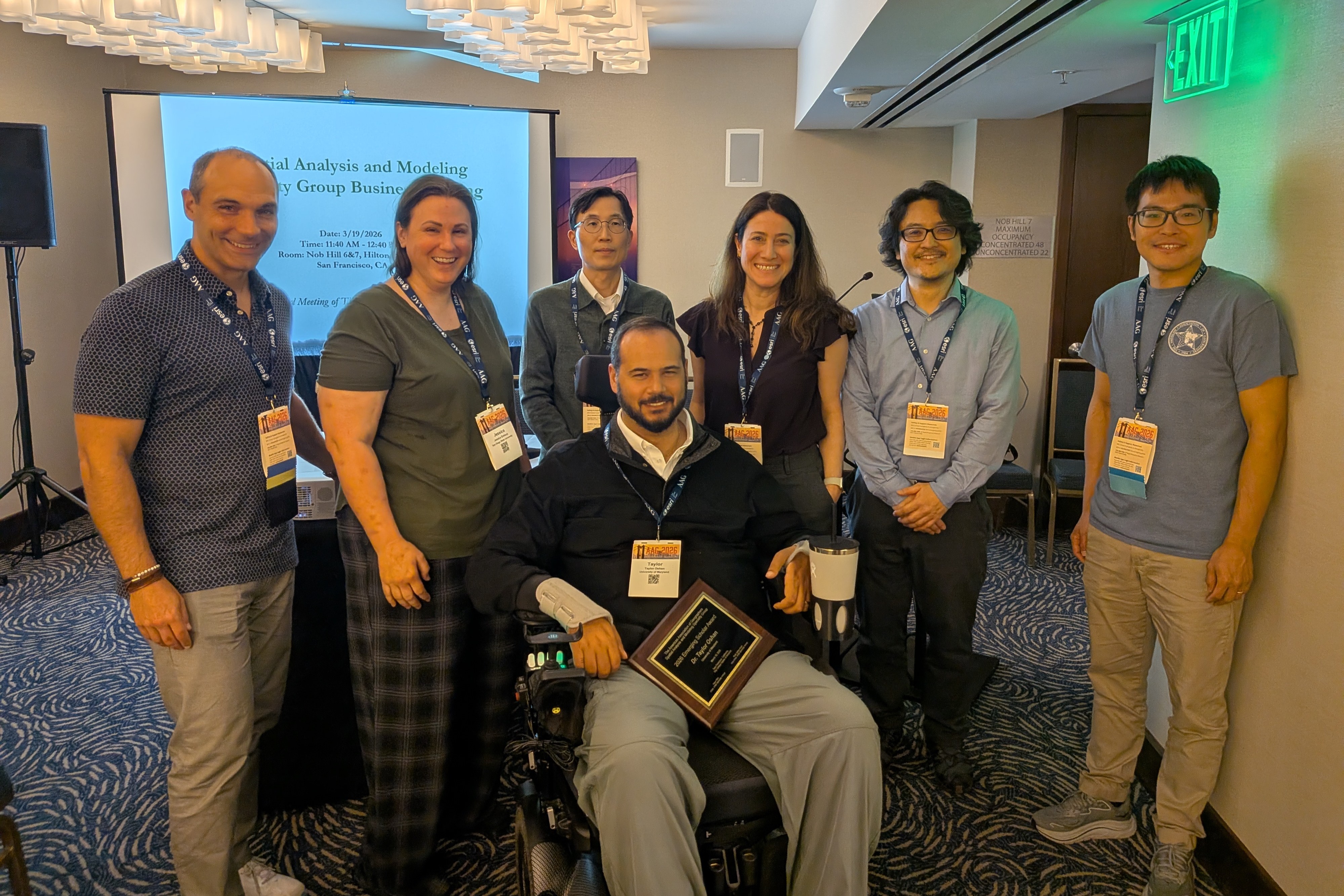
Peter Kedron, Jessica Embury, Hyun Kim, Taylor Oshan, Seda Şalap-Ayça, Atsushi Nara, & Ziqi Li
2026 AAG Symposium on GeoAI and Deep Learning for Geospatial Research
Advance in Causal Inference in Spatial Analysis and Transportation Geography
Artificial Intelligence in Urban Climate Action: Integrating Data, Science, and Planning
Causal Analysis in Geography
Geospatial Analysis and GeoAI for E-Mobility
GIScience at Cal: Celebrating Dr. John Radke’s Academic Career and Retirement
GIScience, Spatial Analysis, and Causal Inference
Movement analytics in the era of big data, AI, and open science
Multiple Hazards, Shared Vulnerabilities: Measuring, Modeling, and Mitigating Urban Heat, Air Pollution, and Flood Risk
Smart Urban Governance & e-Planning
The 12th Symposium on Human Dynamics Research
Detroit, MI: March 24-28, 2025
Artificial intelligence and complex human-environment systems: Mutual linkages and benefits
Citizen Participation in Urban e-Planning
View session
GeoAI and Deep Learning Symposium: Generative AI - Opportunities and Challenges for GIScience
Research
View session
GeoAI and Deep Learning Symposium: Representing geographic locations in AI models: Methods
and Applications
View session
GeoAI and Deep Learning Symposium: Human-Centered Geospatial Data Science
GeoAI and Deep Learning Symposium: Spatial Data Science and GeoAI Ethics: Bridging Research
and Education
View session
GeoAI and Deep Learning Symposium: Spatially Explicit Machine Learning and Artificial
Intelligence
View session
Harnessing Spatial Analysis for Animal Conservation
View session
Human Mobility Patterns in Response to Natural Hazards
View session
Integrative future-oriented approaches for transformative socio-environmental change
View session
Metrics and Beyond: Exploring the Structural Drivers of Health & SDOH
Navigating the Urban Heat Crisis: Science, Solutions, and Social Equity
Spatiotemporal Changes, Socio-Environmental Impacts, and GeoAI in Human Mobility and Homelessness Studies
Symposium on Geospatial Approaches to Pressing Grand Challenges: Global Pandemic, Climate
Change, and Food Security - Spatial Analysis for Social Good
View session
The Interesting Data and Methods Session
View session
Spatial Analysis and the Urban Systems of Cities
View session
Urban Health Dynamics: Exploring Spatial Patterns and Environmental Influences
Virtual Conference: April 7-11, 2021
Spatial Analysis and Modeling (SAM) / Geographical Analysis Plenary
The John Odland Award SAM Student Paper Competition
Spatial Analysis and Modeling Specialty Group Business Meeting
Symposium on Human Dynamics Research
Urban Data Science
Spatial Statistics
Other Emerging Topics
Washington, DC: April 3-7 2019
Advances in Computational Approaches for Geospatial Health Applications
Agriculture and Food Systems: Interdisciplinary Perspectives I and II
Agent-Based Modeling of Human-Environment Interactions
Automated GISci for Network-based Decisions
Computational Geography
Conservation GIS
Cyber-infrastructure: Innovations, Practices and Beyond
GeoAI and Deep Learning Symposium: Deep Learning of Geospatial Patterns & Applications
GeoAI and Deep Learning Symposium: Spatio-Temporal Modeling and Data Mining
Geography, GIScience, and Health: Building an International Geospatial Health Research Network (IGHRN)
Geography, Substance Use, and Addiction
GIScience and Hazards in the Era of Big Data
GIScience in the Post-Truth Era
GIS-based quantitative methods for land change science
Global South Cities: Impacts Due to Physical Transformations in Environment and Landuse
Human Mobility, Environmental Contexts, and Geospatial Data Mining
Integrating Remotely-Sensed Data into Climate Models
Integrative modeling for CHANS
Land Systems Science Symposium
Missing Data? Conceptualizing and making sense of the absence of data in a data-abundant age
Methods and motivations for measuring spatial inequality & socioeconomic mobility
Mountain Futures
Multimodal Visualization for Smart Cities?Urban data as Augmented Reality, Virtual Reality and Multidimensional Visualizations
Multi-source Remote Sensing for terrestrial ecosystem health monitoring and assessment
Point-Based Data for Entrepreneurship Research: Methods, Applications, and Comparisons
Remote sensing applications in sustainable urban science
Smart Cities and Urban Computing
Social Media and Big Data
Spatial and Spatio-temporal Data Mining
Spatial Optimization and Analysis
Spatial-Social Networks in GIS
Spatiotemporal disease mapping and analysis
Sustainability - A Roadmap for Decision Making
Symposium on Frontiers in Geospatial Data Science
Symposium on Human Dynamics Research in the Age of Smart/Intelligent Systems
Symposium on Human Dynamics Research in the Age of Smart/Intelligent Systems: Sensing Human Dynamics for Smart Urban Functions
Symposium on GeoAI and Deep Learning for Geospatial Research
Trees in the City 2019: Socio-Ecological Dynamics in the Urban Forest
Urban Crime Mapping and Analysis Using GIS
Urban Data Science: Methods & Models for Our Changing Cities
Urban Neighborhoods & Health Disparities
Using Coupled Human-Hydrologic Approaches to Advance Water Management and Governance
Using Spatial Data Exploration and Analysis to Understand Educational Inequalities
Chicago, IL: April 21-25, 2015
Spatial Analysis and Modeling Plenary Lecture and Geographical Analysis Reception
[Spatiotemporal Symposium] Time Geography: Integrating Space with Time in Geographic Research (I)
[Spatiotemporal Symposium] Time Geography: Integrating Space with Time in Geographic Research (II)
[Spatiotemporal Symposium] Time Geography: Integrating Space with Time in Geographic Research (III)
Advanced Techniques for Remote Sensor Data Analysis in Urban Areas
Advances in geospatial emergency management
Analysis and Modeling of Landscape Change I
Analysis and Modeling of Landscape Change II
Big Data - Perils and Promises
Big Spatiotemporal (BiST) Data Analytics - I
Big Spatiotemporal (BiST) Data Analytics - II
CyberGIS Symposium: CyberGIS for Modeling Spatiotemporal Uncertainty
CyberGIS Symposium: CyberGIS Foundations and Principles
CyberGIS Symposium: Frontiers of Geographic Data Science
CyberGIS Symposium: Novel CyberGIS Applications
Emerging Issues in Land Systems Science
Frontiers of Spatial Autocorrelation
Geospatial Analysis of Disasters and Hazards
Health Disparities: Contemporary and Emerging Methods
Human Dynamics in the Mobile Age I
Human Dynamics in the Mobile Age II
Human Dynamics in the Mobile Age III
Human Dynamics in the Mobile Age IV
Human Dynamics in the Mobile Age V
Integrating remote sensing and geospatial models in monitoring and assessing surface water quality
Intra-urban Dyanamics II: Land Use and Urban Morphology
Intra-urban Dyanamics III: Policy and Governance
Intra-Urban Dynamics I: Neighborhood Change
Land Change Modeling I: Concepts and Methods
Land Change Modeling II: Applications and Decision Making
Looking Backwards and Forwards in Participatory GIS
Looking Backwards and Forwards in Participatory GIS: Session II
Looking Backwards and Forwards in Participatory GIS: Session II
Looking Backwards and Forwards in Participatory GIS: Session III
Mobile Computing, Activity Space, and Social Networks: Health Applications from NIH Projects
Modeling human population - methods and applications of the WorldPop project
Multi-temporal Analysis of Remote Sensing Data: Methods and Applications I
Multi-temporal Analysis of Remote Sensing Data: Methods and Applications II
Payments for Ecosystem Services: Paths toward Sustainability (I)
Payments for Ecosystem Services: Paths toward Sustainability (II)
Public Transportation, GIS, and Spatial Analysis
Remote Sensing Techniques for Population Characterization
Spatial Analysis and Modeling Specialty Group Business Meeting
Spatial Analysis and Modeling Specialty Group Student Paper Competition
Spatial Data Mining and Big Data Analytics (1)
Spatial Data Mining and Big Data Analytics (2)
Spatial Data Mining and Big Data Analytics (3)
Spatial Data Mining and Big Data Analytics (4)
Spatial Data Mining and Big Data Analytics (5)
Spatial Data Mining and Big Data Analytics (6)
Spatial Data Mining and Big Data Analytics (7)
Spatial Epidemiology I: Accessibility
Spatial Epidemiology II: Spatial Patterns and Clustering
Spatial Epidemiology III: Infectious and vector-borne diseases
Spatial Epidemiology IV: Geospatial analysis and prevention
Spatial Epidemiology V: Spatial analysis
Spatial Optimization and Analysis I
Spatial Optimization and Analysis II
Spatiotemporal Symposium: Data Analysis and Modeling
Spatiotemporal Symposium: Emerging Topics in Data-driven Geography (1)
Spatiotemporal Symposium: Emerging Topics in Data-driven Geography (2)
Spatiotemporal Symposium: Environmental Change Modeling
Spatiotemporal Symposium: Human behaviors
Spatiotemporal Symposium: Public Health
Spatiotemporal Symposium: Space-time dynamics of socio-economic systems I
Spatiotemporal Symposium: Space-time dynamics of socio-economic systems II
Spatiotemporal Symposium: Spatio-temporal analysis and modeling of social networks
Spatiotemporal Symposium: Spatiotemporal Variations and their Impacts on Geographic Models
Urban Emergency Issues under Critical Infrastructure Disruption
Tampa, FL: April 8-12, 2014
Advances and Challenges in Digital Elevation Models I (Overview)
Advances and Challenges in Digital Elevation Models II (Coastal)
Advances and Challenges in Digital Elevation Models III (Remote Sensing)
Advances and Challenges in Digital Elevation Models IV (Geomorphology)
Advances and Challenges in Digital Elevation Models V
CyberGIS and Digital Epidemiology
Evaluating Payments for Ecosystem Services Evidence from a Chinese nature reserve I
Evaluating Payments for Ecosystem Services Evidence from a Chinese nature reserve II
Evaluating Payments for Ecosystem Services Evidence from a Chinese nature reserve III
Frontiers of Spatial Autocorrelation
Geographically Weighted Regression (GWR) 2
Geographically Weighted Regression (GWR)
Geographies of Mobility I Migration
Geographies of Mobility II Transportation and Land Use
Geographies of Mobility III Emerging Mobilities
Geographies of Mobility IV Mobility, Marginalization, and Exclusion
Geographies of Mobility V Climate Change, Disaster and Resilience
Geographies of Mobility VI Methodological Developments
Geographies of Mobility VII Methodological Developments
Geosimulation Models 1 Methodological Advances
Geosimulation Models 2 Applications - Micro to Macro
Geosimulation Models 3 Applications - Macro
Handling attribute data uncertainty in geographical analysis
Health Care Workforce Geography
How can we make agent-based models more relevant
Human Dynamics in the Mobile Age Linking Physical and Virtual Spaces I
Human Dynamics in the Mobile Age Linking Physical and Virtual Spaces III
John Odland Award (SAM Student Paper Contest) I
John Odland Award (SAM Student Paper Contest) II
Land Change Modeling I Methods and Techniques
Land Change Modeling II Applications and Decision Making
Location Privacy Panel Discussion - A
Location Privacy Panel Discussion - B
Location Privacy Paper Session - C
Location Privacy Paper Session - D
Multi-temporal Analysis of Remote Sensing Data Methods and Applications I
Multi-temporal Analysis of Remote Sensing Data Methods and Applications II
Open GIS Problems and prospects (I)
Open GIS Problems and prospects (II)
Paths toward Sustainable Payments for Ecosystem Services--I
Paths toward Sustainable Payments for Ecosystem Services--II
Spatial Analysis and Modeling Plenary Lecture and Geographical Analysis Reception
Spatial Analysis and Modeling Specialty Group Business Meeting
Spatial Epidemiology I Spatial association spatial modeling
Spatial Epidemiology II Spatial association spatial modeling
Spatial Epidemiology III Accessibility
Spatial Epidemiology IV Accessibility
Spatial Epidemiology V Modeling Vector Borne Diseases
Spatial Epidemiology VI spatial modeling
Spatial Optimization and Analysis I
Spatial Optimization and Analysis II
Spatial Optimization and Analysis III
Spatiotemporal Thinking Computing and Applications 1 General Introduction
Spatiotemporal Thinking Computing and Applications 10 Transportation
Spatiotemporal Thinking Computing and Applications 2 Methods
Spatiotemporal Thinking Computing and Applications 3 Pattern Dynamics
Spatiotemporal Thinking Computing and Applications 4 Land Change
Spatiotemporal Thinking Computing and Applications 5 Urban Dynamics
Spatiotemporal Thinking Computing and Applications 6 Natural Hazards
Spatiotemporal Thinking Computing and Applications 7 Public Health
Spatiotemporal Thinking Computing and Applications 8 Agent Based Modeling
Spatiotemporal Thinking Computing and Applications Panel
Sustainability Learning Communities Network
Symposium on Synergistic Advances of CyberGIS and Geography CyberGIS Body of Knowledge
Symposium on Synergistic Advances of CyberGIS and Geography CyberGIS Education
Symposium on Synergistic Advances of CyberGIS and Geography CyberGIS for Taming Big Data
Time Geography New Research Directions Developments and Applications (I)
Time Geography New Research Directions Developments and Applications (II)
Time Geography New Research Directions Developments and Applications (III)
Los Angeles, CA: April 9-13
Advances and Challenges in Digital Elevation Models I (Overview)
Advances and Challenges in Digital Elevation Models II (Coastal)
Advances and Challenges in Digital Elevation Models III (Geomorphology)
Advances and Challenges in Digital Elevation Models IV (Remote Sensing)
Advances and Challenges in Digital Elevation Models V (Illustrated Paper)
Agent-Based & Cellular Automata Models for Geographical Systems 1 Methodological Advances
Agent-Based & Cellular Automata Models for Geographical Systems 2 Land-Use Models
Agent-Based & Cellular Automata Models for Geographical Systems 3 Applications
Agent-Based & Cellular Automata Models for Geographical Systems 4 Applications
Computational and Statistical Methods for Spatiotemporal Data Analytics
Crime Modeling and Mapping (i)
Crime Modeling and Mapping (ii)
Crime Modeling and Mapping (iii)
Cross-Scale Hydrologic Modeling Challenges & Progress
CyberGIS Symposium CyberGIS and Sustainability Sciences - Approaches Cases and Concepts
CyberGIS Symposium CyberGIS and Sustainability Sciences - Making Connections
CyberGIS Symposium CyberGIS Applications
CyberGIS Symposium CyberGIS Education
CyberGIS Symposium CyberGIS for Taming Big Data
CyberGIS Symposium CyberGIS Linked Data and Geospatial Semantics
CyberGIS Symposium Frontiers and Roadmaps - Academic Viewpoints
CyberGIS Symposium GIS&T BoK - Making Space for Knowledge
CyberGIS Symposium Industry Perspectives
CyberGIS Symposium Science of CyberGIS
CyberGIS Symposium Technologies and Social Dimensions
CyberGIS Symposium Time Geography I
CyberGIS Symposium Time Geography II
Frontiers of Spatial Autocorrelation
Geo-Health Research at NIH Issues in modelling population based cancer statistics
Geography and Mobile Phone Data is there a privacy caveat
Healthcare Workforce Geography
John Odland Award (SAM Student Paper Competition) I
John Odland Award (SAM Student Paper Competition) II
Land Change Modeling Concepts Techniques and Applications
Land Systems Science Closing Plenary
Land Systems Science Opening Plenary
Land Systems Science Symposium Analysis and Modeling of Change I
Land Systems Science Symposium Analysis and Modeling of Change II
Land Systems Science Symposium Case Studies - Africa
Land Systems Science Symposium Case Studies - Amazonia
Land Systems Science Symposium Case Studies - Asia
Land Systems Science Symposium Case Studies - Latin America
Land Systems Science Symposium Case Studies - N America I
Land Systems Science Symposium Case Studies - N America II
Land Systems Science Symposium Environmental Dimensions of Land Systems
Land Systems Science Symposium Human Dimensions of Land Systems I
Land Systems Science Symposium Human Dimensions of Land Systems II
Land Systems Science Symposium Issues in Land Systems Science I
Land Systems Science Symposium Issues in Land Systems Science II
Land Systems Science Symposium Panel on LUCC-ABM
Land Systems Science Symposium Plenary Lecture
Location Analysis and Modeling I
Location Analysis and Modeling II
Location Analysis and Modeling III
Location Analysis and Modeling IV
Methods for Capturing Complex Joint Effects in Small Area Social Analysis
Multi-temporal Analysis of Remote Sensing Data Methods and Applications I
Multi-temporal Analysis of Remote Sensing Data Methods and Applications II
Payments for Ecosystem Services Paths toward Sustainability--Session I
Payments for Ecosystem Services Paths toward Sustainability--Session II
Spatial Analysis and Modeling Plenary Lecture and Geographical Analysis Reception
Spatial Analysis and Modeling Specialty Group Business Meeting
Spatial Analysis Methods for Historical Census Demography
Spatial and Spatio-Temporal Data Mining & Visualization (1) Events and Trajectories
Spatial and Spatio-Temporal Data Mining & Visualization (2) Regionalization and Community Detection
Spatial and Spatio-Temporal Data Mining & Visualization (3) Social Data Mining
Spatial and Spatio-Temporal Data Mining & Visualization (4) Geo-Social Networks
Spatial and Spatio-Temporal Data Mining & Visualization (5) Movement Pattern Analysis
Spatial and Spatio-Temporal Data Mining & Visualization (6)
Spatial Optimization and Analysis I
Spatial Optimization and Analysis II
Spatio-temporal Analysis of Vector-borne Disease I
Spatio-temporal Analysis of Vector-borne Disease II
Spatiotemporal Thinking Computing and Applications 10 Computing Panel
Spatiotemporal Thinking Computing and Applications 2 Thinking
Spatiotemporal Thinking Computing and Applications 3 Methodologies
Spatiotemporal Thinking Computing and Applications 4 Thinking Panel
Spatiotemporal Thinking Computing and Applications 7 Big Data
Spatiotemporal Thinking Computing and Applications 8 Software Tools
Spatiotemporal Thinking Computing and Applications 9 Agent based modeling
Seattle, WA: April 12-16, 2011
SAM Plenary Lecture Featuring Dr. Geoffrey Jacquez
Time Geography: Recent Progress and Future Prospects
Online visualization for geospatial sciences
Social-ecological systems: theory, methods, and modeling
Interpolation and Uncertainty in Small-Area Estimates
Open Source Tools in GISc Research and Education
Monitoring landscape-scale disturbance and recovery with remote sensing
Washington, DC: April 14-18, 2010
Call for Papers: Modeling Geographic Complexity
Call for Papers: Time Geography: Its Past, Present and Future
Call for Papers: Modeling Opium Poppy
Call for Papers: Crime Modeling and Mapping
Call for Papers: Geographically Weighted Regression
Call for Papers: Classification Approaches in Neighborhood Research
Call for Papers: In These Tough Economic Times (ITTET): Analyzing Recession Geography
Call for Papers: New Methods in Point Pattern Analysis
Call for Papers: High Performance Computing for Geographic Sciences
Call for Papers: Open Source Tools & Standards in GISc Research and Education
Call for Papers: Geospatial methods and applications for biodiversity monitoring and conservation
Call for Papers: Modeling H1N1
Call for Papers: Spatial Interactions: Analysis and Modeling
Call for Papers: Location and Spatial Analysis
Call for Papers: Analysis of Multi-temporal Remotely Sensed Data: Methods and Applications
Call for Papers: Emerging Trends in Geographic Data Analysis for Population Characterization
Las Vegas, NV: March 22-27, 2009
SAM Specialty Group Student Paper & Emerging Scholar Paper Competitions
Call for Papers: Transport Efficiency - Fact or Fiction?
Call for Papers: Critical Network Infrastructure
Call for Papers: Time Geography
Call for Papers: Emerging Infectious Diseases
Call for Papers: Spatial Autocorrelation and Environmental Justice
Call for Papers: Geographic Complexity
Call for Papers: Mapping the Census